


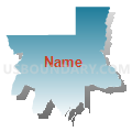
Holbrook Voting District, Oneida County, Idaho
About
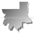
Outline

Summary
| Unique Area Identifier | 564331 |
| Name | Holbrook Voting District |
| County | Oneida County |
| State | Idaho |
| Area (square miles) | 331.25 |
| Land Area (square miles) | 331.21 |
| Water Area (square miles) | 0.03 |
| % of Land Area | 99.99 |
| % of Water Area | 0.01 |
| Latitude of the Internal Point | 42.23235610 |
| Longtitude of the Internal Point | -112.66569920 |
Maps

Graphs
Select a template below for downloading or customizing gragh for Holbrook Voting District, Oneida County, Idaho


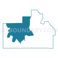
Neighbors
Neighoring Voting District (by Name) Neighboring Voting District on the Map
- Voting District 077004, Power County, ID
- Voting District 077005, Power County, ID
- Curlew Voting District, Oneida County, ID
- Malad 1 Voting District, Oneida County, ID
- Malad 4 Voting District, Oneida County, ID
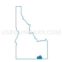
Top 10 Neighboring County Subdivision (by Population) Neighboring County Subdivision on the Map
- Malad City CCD, Oneida County, ID (3,931)
- Rockland CCD, Power County, ID (650)
- Holbrook CCD, Oneida County, ID (355)
- Arbon CCD, Power County, ID (181)
Top 10 Neighboring Unified School District (by Population) Neighboring Unified School District on the Map
- Cassia County Joint School District 151, ID (22,454)
- Oneida County School District 351, ID (4,240)
- Rockland School District 382, ID (549)
- Arbon Elementary School District 383, ID (139)